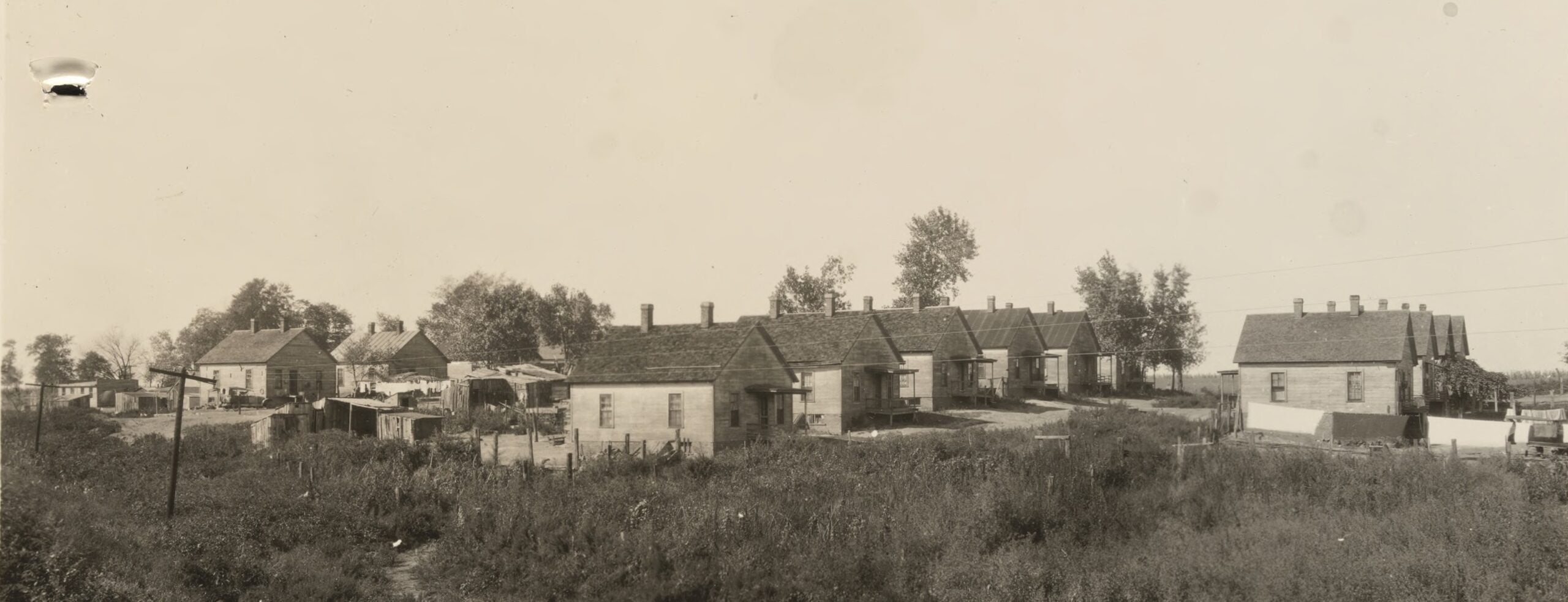
Miner’s cottages in the Rochester Township community of Keys, 1923. See below for more about this photo (University of Illinois History and Lincoln Collections)
Editor’s note: The Tuxhorn Coal Mine operated under various names from 1903 until about 1924 in the Round Prairie/Rochester area of Sangamon County. A small community, known as Keys or Keys Station, grew up around the mine. You can read about the mine and the town of Keys in a previous SangamonLink entry written by area resident Leslie Struble.
In 2026, Michael J. Melton, a resident of one of the two remaining miners’ homes at Keys, discovered that online bookseller AbeBooks was selling a photo collection produced in 1923 by the Leland Coal Co., which at the time owned a half-dozen central Illinois mines, including the Tuxhorn Coal Company/Union Fuel Company mine. The collection included several photos of Keys and the Tuxhorn mine.
By the time Melton learned of the photos, the University of Illinois Library had purchased the images for its Illinois History and Lincoln Collections.
The photos are signed by photographer E.G. Wade (1887-1932). An Alton native, Wade opened the Crystal Studio, a photography business on the north side of the Springfield square, in early 1924. His announcement said he had “perfected a process” for color photography. However, the business was short-lived. Wade next was employed briefly at the Ray Georg studio in Springfield but moved to Peoria in late 1925 for another photography job. Wade was back in Alton, working in sales, when he died.
AbeBooks’ commentary on the set of images included the following:
These 38 very lovely, well-composed shots are divided into views of six different mines, in Nilwood, Keys, Auburn, Athens, Selbytown and Girard, respectively, and each has a typed and stamped caption (matching the list) adhered to its edge. The photos show a range of mining sites, such as the “Office and Wash House,” “Power and Engine House,” “Miners Dwellings” and “Supply Buildings,” just to name a few. They show “tipples,” “fens” and “escapements” and most indicate the direction of the view. Four additional captioned photos of Girard’s Mine Number 6, similarly striking, by another Springfield photographer, Harry E. Neef, are also included. Fantastic, well-captioned images of 1920s mining operations in Illinois.
Melton obtained the Leland Coal Co. photos from the U of I and provided them to SangamonLink.
Two other photos also are known to exist of the Tuxhorn Mine and Keys. Those were taken about 1918 for the Orange Judd Farmer Pictorial Community Album of Rochester Township and Village. The originals of those photos apparently no longer exist; the Orange Judd Co. went out of existence in the early 20th century.
One other reproduction note: The originals of E.G. Wade’s 1923 photos, the images Melton worked with, also are much sharper and more detailed than what you see on SangamonLink. Melton’s comments below include a couple references to blurred images of a worker atop a coal gondola. In the originals, it’s clear that the images, while blurred, show a worker; in our reproductions, the photos show only whitish shadows. In another photo, Melton refers to a sign that says “Danger Explosives”; that sign can’t be read in the SangamonLink photo. These deficiencies simply reflect SangamonLink’s reproduction limitations.
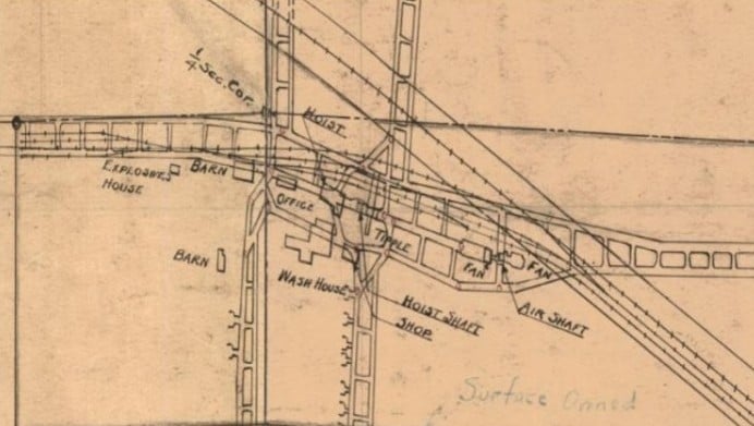
Map shows mine layout and relationships between many of the structures shown below (Illinois State Geological Survey)
Melton wrote the commentary below, with light editing by SangamonLink. Melton’s discussion covers both the 1918 Orange Judd photos and the 1923 photographs taken by E.G. Wade. The photographs provide striking views of the structure of a working coal mine and the hardscrabble environment central Illinois miners endured during the early 20th century.
Struble put Melton in contact with SangamonLink in 2026. Our thanks to both of them.
Michael J. Melton comments
The photo album was an internal product of the Leland Coal Co., which owned the Union Fuel Co. mines in Illinois. I came across an AbeBooks advertisement for it this year (2026) while once again searching for anything Tuxhorn related. It was luck, because the ad was recently placed in April 2026. Otherwise, I would have found nothing new. AbeBooks informed me that the U of I was the buyer, and of course I went there next. The U of I graciously scanned the photos.
Orange Judd album photos, 1918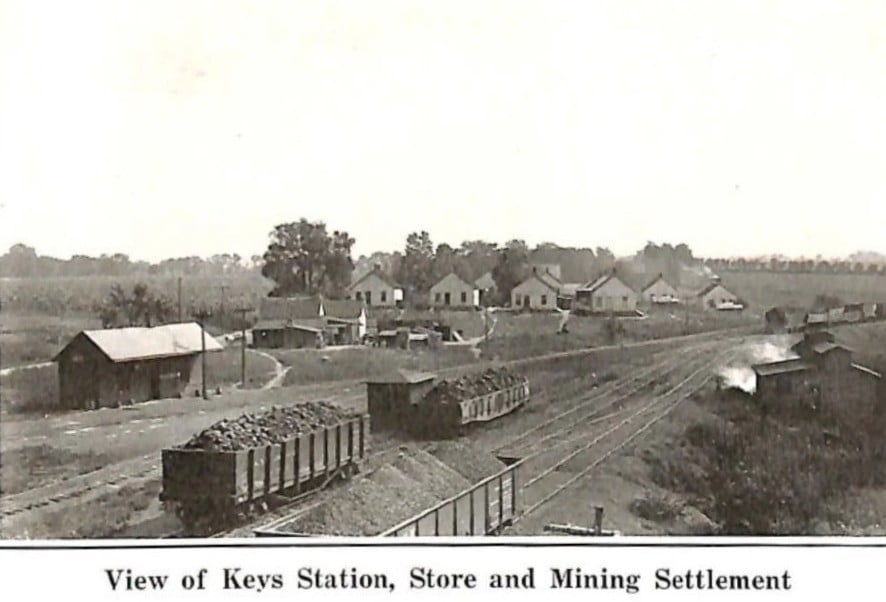
Looking east in the top photo, my house is the first on the left in the front row of four, one of only two homes still in their original locations since 1903. My garage is exactly where the second house from the left sat. The third and fourth houses from left in the front row, and nearly all the others, are long gone, either moved or torn down sometime after the mine closed in 1924. However, remnants of the fourth house’s red brick foundation are still visible in the yard where the garden is now. I mention this because the first time I tilled that garden in 1996, I inadvertently unearthed many buried bricks, but also because the fourth house serves as a landmark to relate a few of these photos.
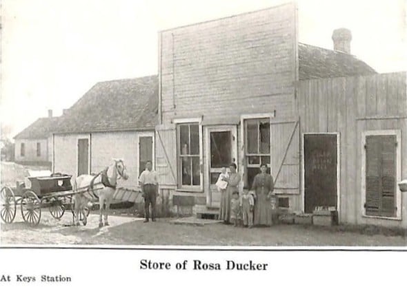
The structure in front of the houses is presumably the general store of Rosa Ducker (DeCroix), shown in the bottom photo; however, I cannot reconcile the store’s rooflines between the two Orange Judd photos. The Old West-style square false front of the store cannot be made out in the village photo, although it seems the horse and wagon might have stayed in the same place in the road between the two photos.
To the left of the general store in the top photo is the Keys Station railroad depot. Many coal miners lived in Springfield and rode the train. When I moved here in 1993, there was a six-foot-diameter brick-lined open well or cistern right about there, but nothing else. It was sealed just before the property was sold in 1995. By then the entire area was very overgrown, and all railroad tracks and structures had been removed for many decades.
In the center of the top photo is the scale track and a small shed where the loaded railcar weights were recorded. On the right are the mine ventilation fan structures covering the air shaft.
In 1995, the new landowner started clearing the land of overgrowth and dug a large hole to shove the air shaft concrete ruins into. Over the next ten years, they had thousands of tons of fill dirt brought in, creating a plateau, where a large horse barn was built in 2005. The property has since been resold and converted into a house and small farm.
Photos from Union Fuel Co. album (1923)
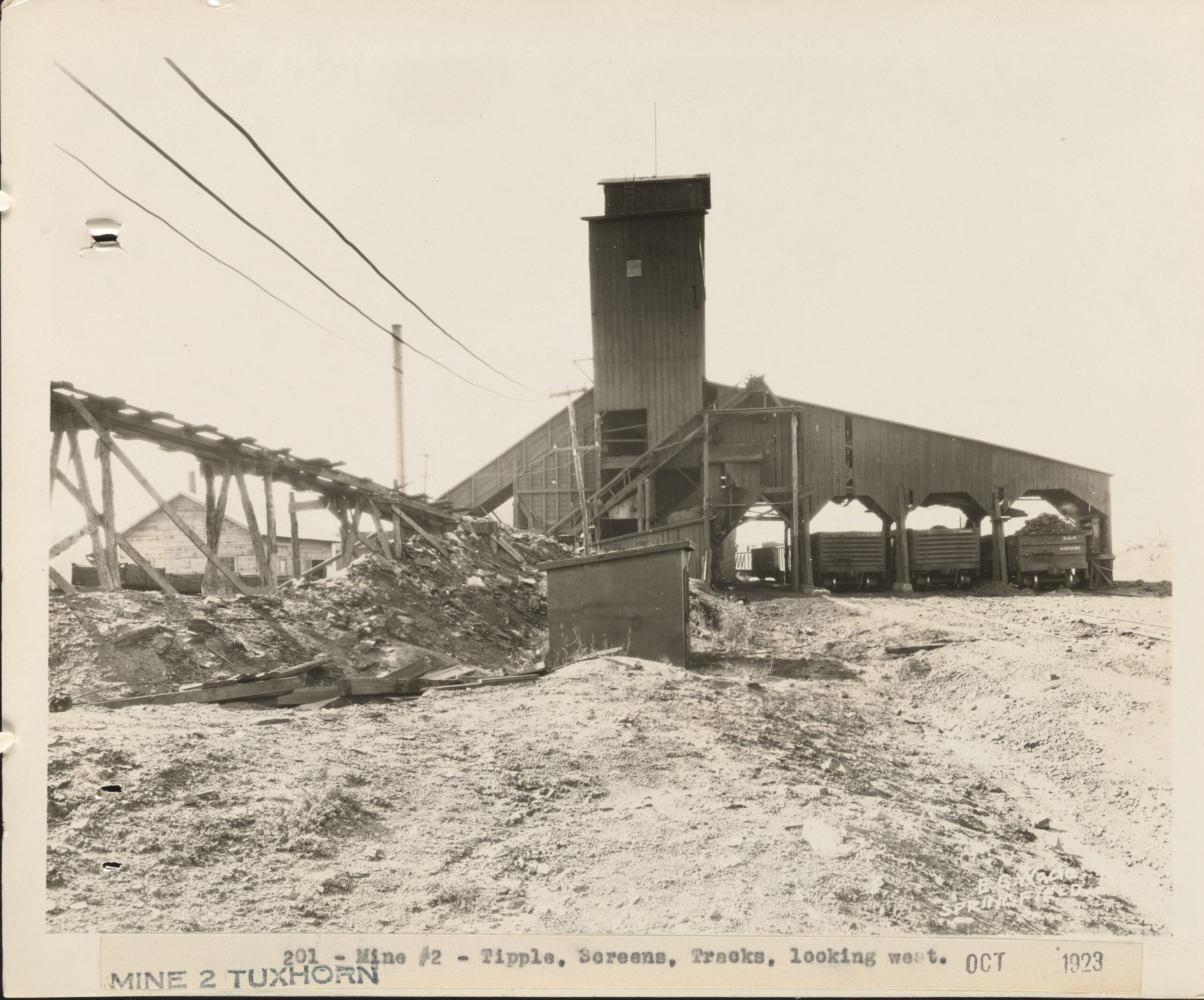 Photo 201: View looking west of tipple. Mine construction notes say the center of the sheaves was set at 66 feet, so I estimate the roof of the tipple structure was around 75-85 feet high. I think the elevated coal car track seen on the left ran over to somewhere near the ventilation shaft, but it’s hard to tell from the photos. My guess is it was used to dump rejected items that were sorted out of the coal at the tipple. The mine blacksmith shop is also seen under that track. Someone viewing the original photo (not reproduced in sufficient detail here – ed.) can see the blur of a moving worker on top of the railroad car on the right. The three coal gondolas are property of the B&O and Illinois Central railroads.
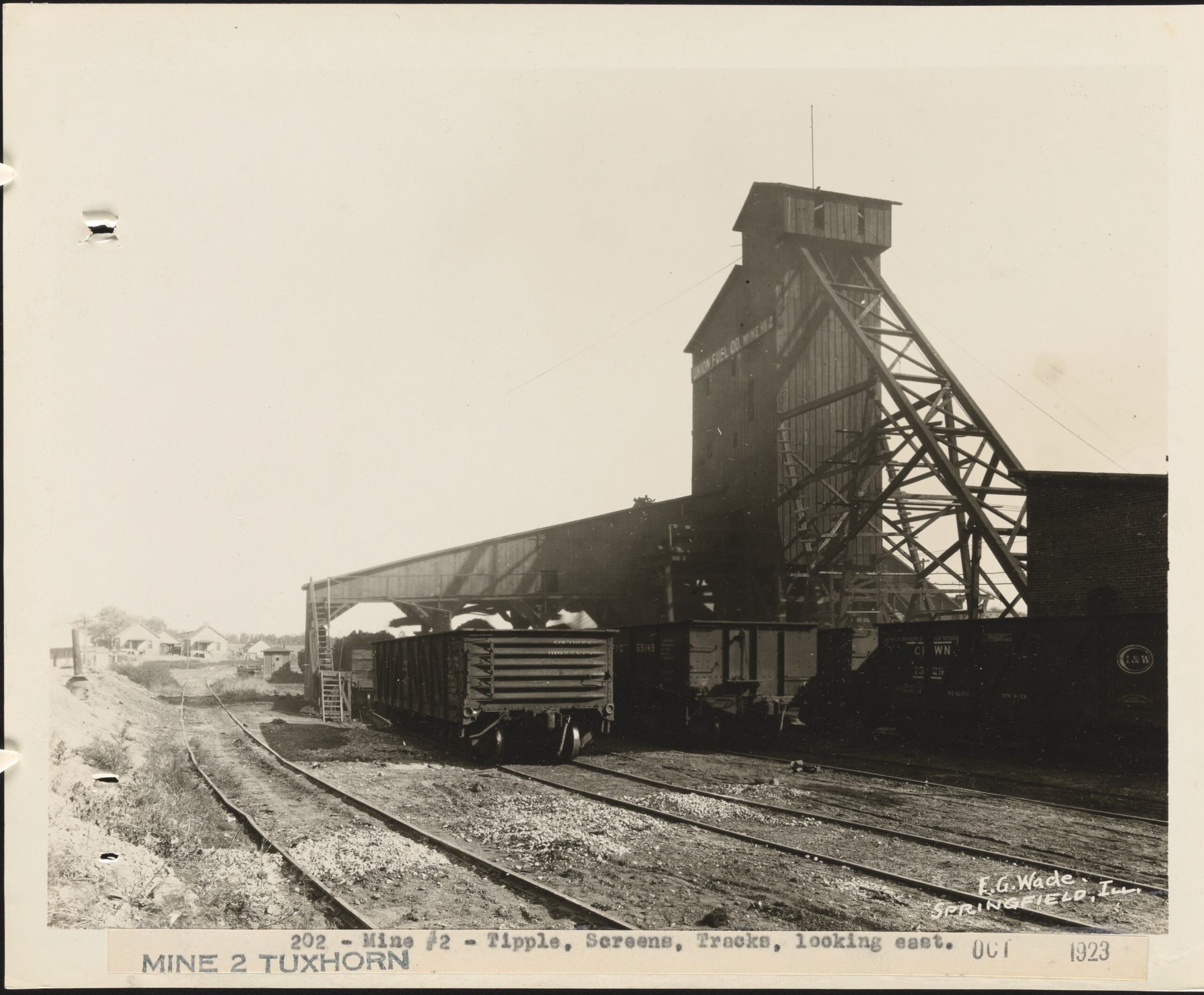 Photo 202: View looking east of tipple, a lot of detail in this photo. The Union Fuel Co. Mine No. 2 sign high on the tipple, the railroad tracks buried in dirt, rock and coal. Large diagonal bracing between the tipple and hoist building. The left track not going under the tipple was used to push empty railcars up a slight incline onto storage sidings to the west. Then they were gravity-rolled under the tipple for loading. I did read that a cable system may have also been employed, as the mine apparently did not own a switching locomotive to shuffle the coal gondolas around.
In the background are the same front-row houses seen in the 1918 Orange Judd photo, the third and fourth from left being most prominent.
The Cincinnati, Indianapolis & Western Railroad ran coal cars through Keys on tracks owned by the Chicago & Alton Railroad. This photo also shows gondolas from the Southern and Union Pacific railroads.
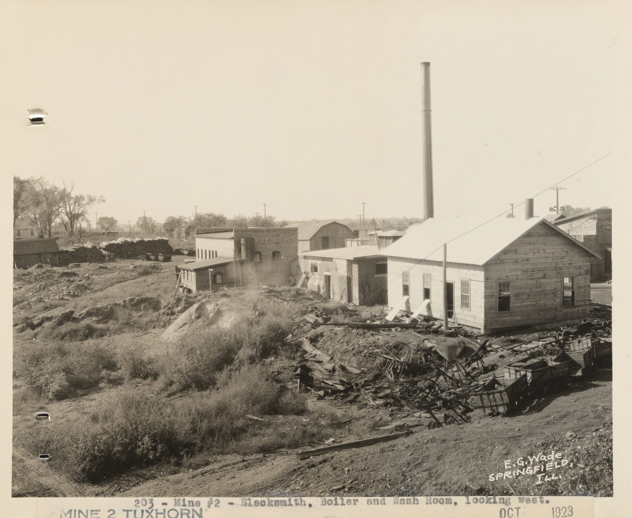 Photo 203: Mine blacksmith shop, wash house, small barn, mule barn, 80-foot-tall chimney, and part of the main shaft hoist engine building. Large amount of coal car wreckage strewn about. A house in the distance looks to have to exact same build as the 14 miner homes. All the utility poles mark Tuxhorn Road. Partially visible in the tree line is the explosives storage structure.
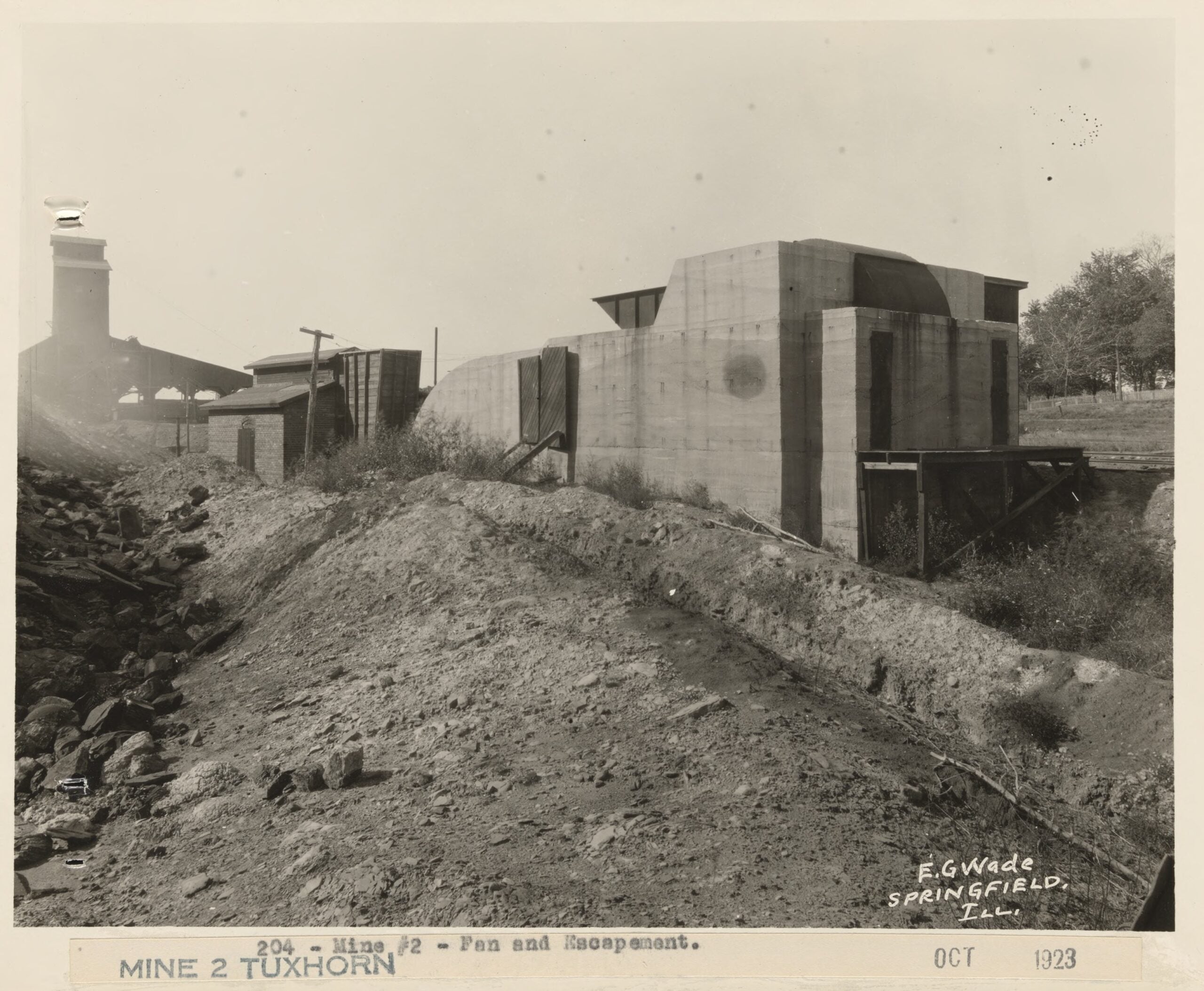 Photo 204: The ventilation fan and air shaft structures, with tipple in the distance. Per mine construction notes, the 220-foot-deep air shaft had a staircase for use as an alternate exit. By 1993, only large overgrown concrete ruins were left, with huge, heavily rusted iron bolts sticking out. It was not obvious what it used to be. Both this and the main shaft were apparently dynamited closed, although many mine structures are still visible in a 1939 aerial photo, so exactly when that happened is a question.
Across the road, a white picket fence can be seen on the small hill that marks the front of the property that now belongs to Tim and Teana Scannell. They took that fence down only a few years ago; it was over 100 years old by then.
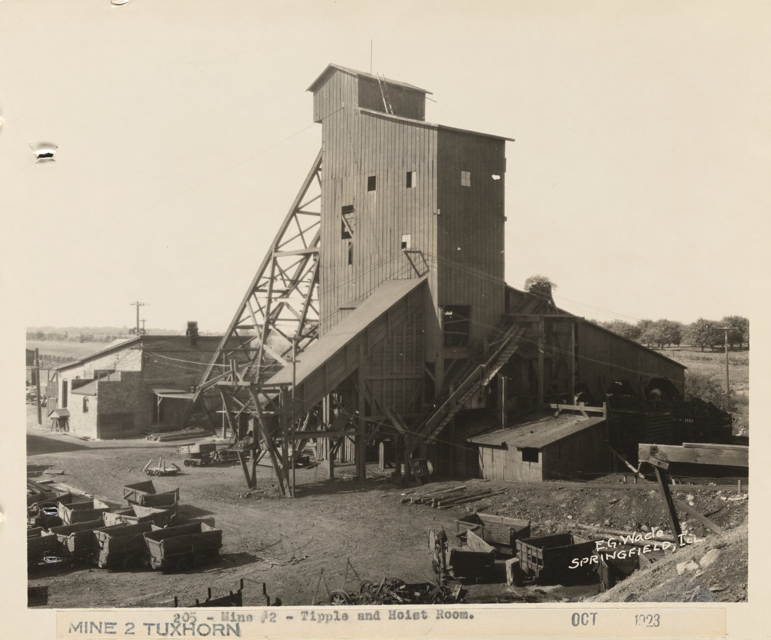 Photo 205: Great angle of tipple and hoist engine building, looking northwest. Coal cars, that elevated track running uphill to the right, the coal chute for loading trucks and wagons, and again the blur of a worker moving around on the coal gondola (center, far right). The electrical wiring shown would have been fairly recent – word is the mine got power before Rochester. The only remaining remnant of this scene today is the concrete foundation for the hoist engine, which was inside the hoist building. I recently got permission to clean the overgrowth off it; it’s now just old concrete and large flame-cut rusted bolts.
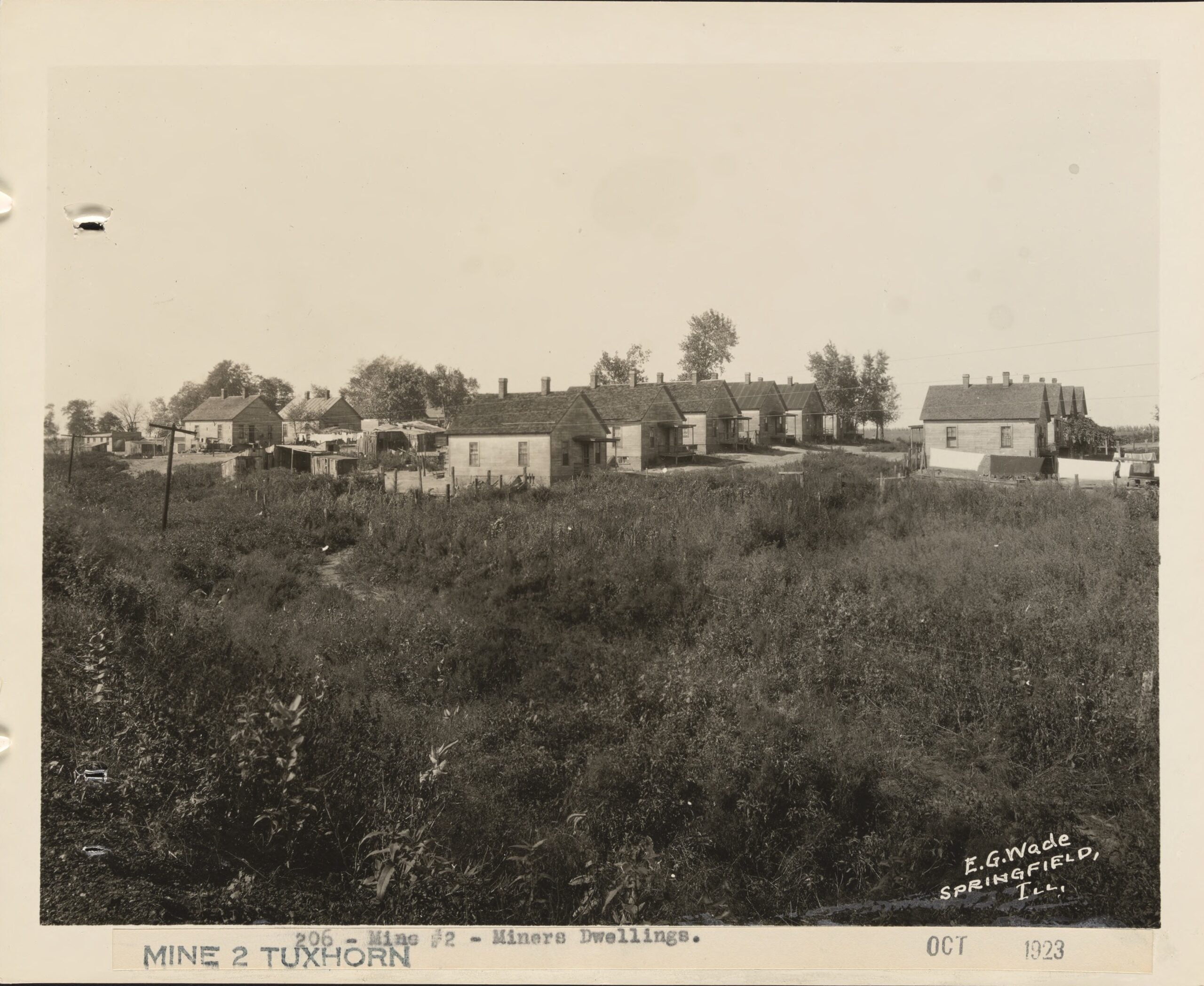 Photo 206: This is the full version of the photograph that begins this entry. It shows all 14 identical miner company homes, viewed from the railroad tracks south of the miner settlement, looking northwest. The house on the left with the old car near it is the same front-row fourth house from the left in the Orange Judd photo – again, where the garden is now. My house cannot be seen at this angle; it is behind the middle row of houses. The farthest house from the photographer in the rightmost row also still stands. All others have been moved or torn down, their cellars filled in. The area is still littered with broken glass, nails, coal clinkers, railroad spikes, bricks, etc.
Note the houses are identical, but each row faces the opposite of its adjacent row. Every house had a cellar with an outdoor covered stairwell through the foundation. Mine was bricked closed long ago, when additions started being added – I believe in the 1940s – mainly to give the house an indoor bathroom! Numerous sheds, old cars, outhouses, wagons, utility poles with the green glass insulators, clothes drying on a line. The cornfield behind the houses and across the road is still a corn and soybean field today.
The back of the general store can barely be seen, or mainly the sheds behind it. I do not know what the structure on far left of photo is, the one with a mostly flat roof. It is not present in the Orange Judd photo of five years prior. I did read a mention in an oral history account of the railroad loading cattle here, but it was without any detail, nor does that structure appear to have anything to do with that.
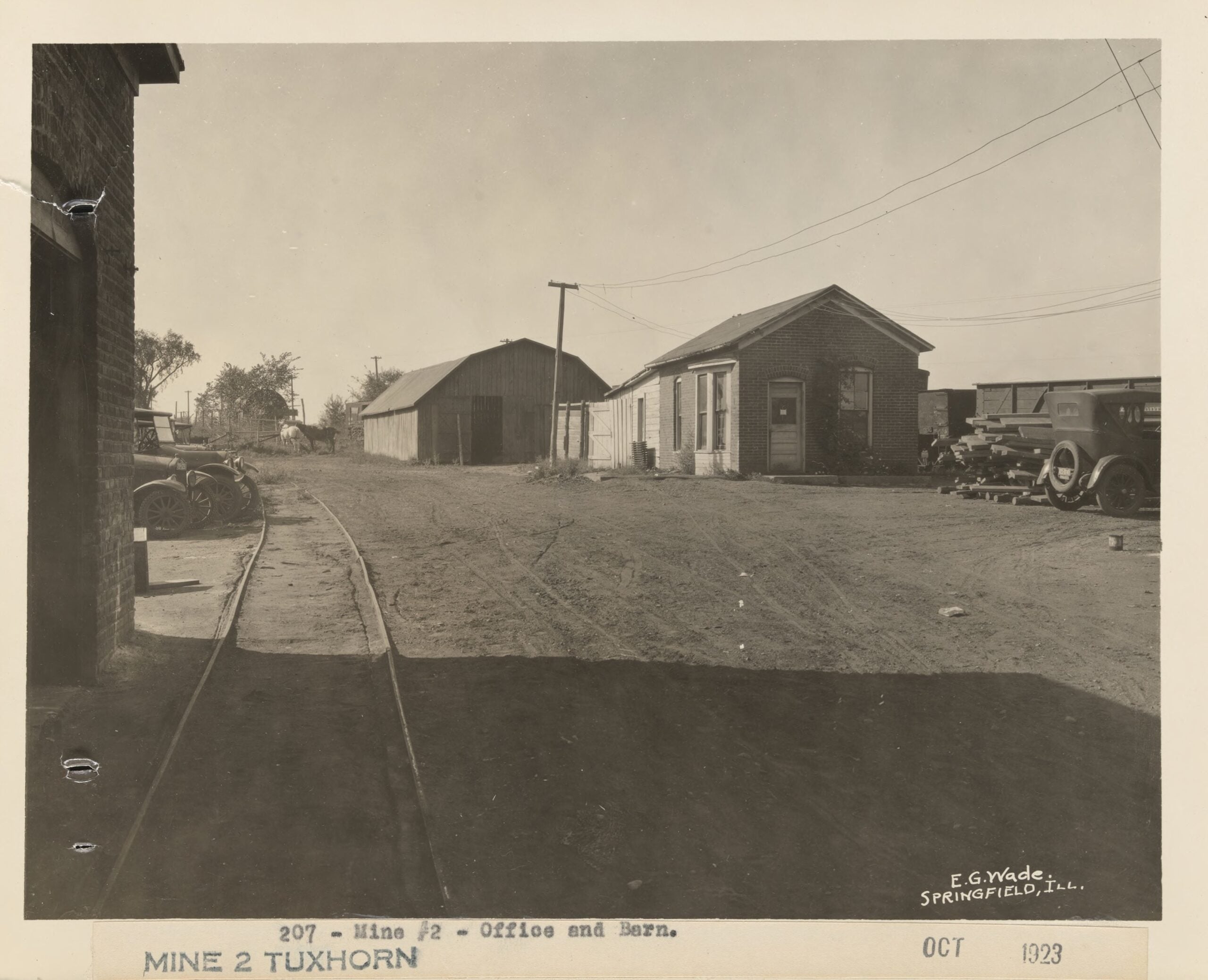
 Photo 207: Mine office, mule barn, and in the distance, explosives storage. The sign above the two horses (not legible in SangamonLink’s reproduction – ed.) reads “Danger Explosives”. I get a kick out of the perforated airless tire on the Model T or whatever make of car it is. I read those tires were popular for rough rural roads. There is an old iron heating radiator leaning against the office. Large wood beams stacked around. I’m left to wonder what the note said that’s hanging in the window of the office door.
Original content copyright Michael J. Melton, published with permission by the Sangamon County Historical Society. Learn how to support the Society.